Sunday, December 8, 2013

Week 9

Tasks

  • Summarize my path through the course


To France and back

On September 14th my Geography of the Western Front class travelled to France for 10 days to study the battlefields of World War I, more commonly known by Europeans as The Great War. The first city we stayed in was Hardecourt-aux-Bois. This city is really close to the Hawthorn and Lochnagar craters and is in the heart of the Somme. Visiting the memorials and battlefields of the Somme are really what drove me to want to focus on The Battle of the Somme for my final project. Some of the WWI memorials we went to were absolutly beautiful. Knowing what I wanted to focus on, I then needed to decide what direction I wanted to go with it.
This is a picture from the Vimy Ridge Canadian WWI Memorial


Before we had left my professor, Joe Hupy, showed us a story map of The Battle of Gettysburg. I really wanted to do something similar to this. I wanted to be able to show on a map how the front lines moved throughout the battle. I also wanted to be able to display some of the locations that I had visited while in France. So I guess you could say both the Gettysburg story map and my own personal experiences in France were my inspiration for my final project.


*** At this point I knew I wanted my final project to focus on The Battle of the Somme, I just wan't sure how my project would be presented.


Story Map Try-outs

When we got back from out trip our professor decided to have us create story maps. The story maps were meant to familiarize us with the programs and help us decide which one we would want to use for our final project. The first program we used was created by Esri. This kind of story map was nice because there were a lot more things you could edit on it and really make it your own. Another pro to using the Esri Story Map was that Esri is probably the most welcomed format within the geography community. Everything geographers use now seems to be run by Esri. The down-side was that the site wasn't very user friendly. Some of the editable features were difficult to use. My Esri Story Map focused on the second day of our trip; Day 2 in France.


My Esri Story Map of the second day of our trip to France


The next and final story map we tried out was created by Google and it is called TourBuilder. I also liked this type of story map, but for different reasons. The TourBuilder program was extremely user friendly. It was very simple to use and took no time at all to figure it out. The cons about this program were that there wasn't as much you could edit on it, so everyone's story maps had the exact same format. Very unoriginal. Another thing that isn't great about this site is the Google isn't as high praised as Esri. My TourBuilder Story Map focused on the memorials we visited from WWI; Memorials of WWI.


My TourBuilder Story Map of the memorials of WWI


*** At this point in the semester I was planning on creating an Esri Story Map on The Battle of the Somme using the Gettysburg format. My hope was for my story map to look very similar to the Gettysburg one. It would be an interactive map that would show the progression of the front lines across the western front. 


Foundation of Research

After completing those two sample story maps I began to go more in-depth with my research on The Battle of the Somme. I already had a solid base of knowledge from my trip to France and learning the essentials from the battle, but for me to make a final project that goes above and beyond I knew I would have to dig a little deeper and find some information that not everyone else knew about. When I first presented my blog post with the information I had found on The Battle of the Somme it mostly consisted of things that I had learned from the assigned text and the France trip. While I'm not going to go over every source that I used for my project I will share my favorite source. I used a lot of sources for different things. A lot were used for finding different maps of the Somme. 

My first favorite source I used was from Spartacus Educational who had an amazing site giving a brief overview of the entire Battle of the Somme. A lot of what we learned while we were in France was about the first day of battle because this is when the most significant events happened. This site went beyond that and explained It did give a description for the first day, but after that it explained the rest of the battle as well. The author proceeds from that first day and talk about the front line changes from July 14th, September 15th, and finally to November 18th at the end of the battle. It explains significant events that led to the front line moves and the reasoning for the end of the battle, or at least a hypothesis for the ending of the battle. This site really helped me gain a greater base of knowledge on The Battle of the Somme for my final project. 


*** At this point I was really just in the gathering of information mode. Even though I was unsure of where my final project was heading I knew I would need a lot of information. So for the time being that was where my focus lied.


ArcGIS Online

ArcGIS Online is the site that the Esri Story Maps came off of. You would pick your basemap and then insert that into a story map and add pictures to different places on the map. Well instead of inserting the map into a template right away I found out that the site lets you draw on the basemap. When I found this out I decided to draw the front lines on the basemap using the Map Notes tab.


Front lines of The Battle of the Somme


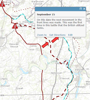
This was the map I used most to help me draw the front lines on the basemap. I spent quite a lot of time tinckering around with this and trying out different features. Once I finished drawing the front lines I was able to add descriptions to the features that I had just created. I added a short summary to each front line movement.

After I finished drawing the front lines I decided to add the two craters that we had visited while we were in France, the Hawthorn and Lochangar craters. These were symbolized by red triangles with an exclamation point in the middle.


A screenshot of what my project looked like up to this point


*** At this point in the semester I was still hoping to find a way to use what I had just drawn on ArcGIS Online to create something similar to the Gettysburg map. I was also looking for a Story Map template to incorporate what I had just created. I had more of an idea of what I wanted to do than a direction of where I was going with it.


Additional data research

After I had the front lines for July 1st, July 14th, September 15th, and November 18th drawn on my map I realized I would need more information represented on my map, it was looking rather blank. My first decision was to add all of the larger mine explosions that occured on the first day to my map. At this point I only had the Hawthorn and Lochnagar craters on my map. Through using several different sites I was able to find the locations of the Triple Tambour, Y-Sap, Bulgar Point, and Casino Point mines.
Although this is more information that was being added to my map it was still looking rather blank. When I came across this next site I immediatly knew what would be next to go on my map. This source, Commonwealth War Graves Commission, focuses on the individual battles withing The Battle of the Somme. So on my map I illustrated each of these smaller battles, which helped show the progression of the Allied troops as they pushed back the imposing German forces. The author did an excellent job describing the events leading from the beginning of the fighting near the city of Albert on outward towards the city of Bapaume and the final front line move on November 18th.


*** At this point in the semester I had all of my information about The Battle of the Somme collected, I just had to figure out how I would display it onto my map. Also I continued to think about how I wanted to present my final project.


Adding new information to my map

I began with adding the mine explosions to my map. I created a new feature class using Map Notes and I placed an orange icon in the places where mine explosions occured. I then added a small bit of information about each cratered area in the description section. Some craters like the Lochnagar Crater only had one mine explosion in that location. Others, like the Triple Tambour site, had multiple mine explosions all in one area. Regardless of the number of explosions, each area only received one orange icon to maintain the maps neatness.


What my map looked like after the addition of the mine explosions


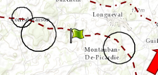
After the addition of the mine explosions I began to add each of the smaller battles on to my interactive map. There were twelve of the smaller battles in all. One problem I had while illustrating these battles was that I wasn't sure how to display them on my map. I came to the decision of circling the areas of emphasis and putting a flag near those areas that contained information about the battle. Green flags were used for successful battles. White flags were used for battles that either failed or were not a complete success. While this worked well for the areas that were taken over by the Allied troops, some of the battles were assaulted that started at one city and progressed to another. These types of battles are displayed with using hollowed out arrows pointing in the direction of the assault. There was then no need for the informational flag because the arrow feature could hold all of the information.


Battle type number 1


Battle type number 2


*** At this point in the semester I finally had all of the information that I wanted displayed on my ArcGIS map. I was still unsure of how I was going to display my map, but I was finally getting close to a final project.


Presentation

While I was looking through all of the Story Map templates that are hosted on the ArcGIS Online site I came across something. Every time I would go to work on my map I would click open and then click open in ArcGIS.com map viewer. There were always other options, but I never bothered to open my map in any other program besides the one we had been working with all semester. I decided to open my map in ArcGIS Explorer Online.

This is the screen that my map opened up into


I was able to turn on and off all of my features just like the other program, but this one had a different function. I clicked on the Presentation tab and I realized how I was going to present my project. The Presentation tab gave me the ability to insert my map and features into a slideshow format. I started off with the first day of fighting with the caption "July 1st" and turned on the July 1 and crater explosion features and turned everything else off. I did this to show all of the battles also. I progressed through The Battle of the Somme slide-by-slide. You can still click on features to see the information I wrote about them. The only thing this format wasn't compatable with was the pictures I attached to the information, so I had to delete those. Other than that I love this format and I believe it displays my research and map excellently.


Final Website: Geography of the Western Front


Monday, December 2, 2013

Week 8

Tasks

  • Complete an overview of my final project to be placed on the class website
 
This week was Thanksgiving Break so not much progress was made concerning my final project. Although I did sit down with my professor before break to go over what I would need to do to Georeference my maps, I didn't have access to a computer over break and not much was completed.


Overview


Background: I am a geography major at the University of Eau Claire, Wisconsin. I’ve always wanted to get the opportunity to travel outside of the country. I mean I’ve been to Canada, but that doesn’t really count! When I found out about the trip to Europe I was immediately intrigued, even though I knew nothing about the class. I found out that during the trip we would be travelling to Europe for ten days to visit WWI battlefields. At this point in my college career I’m not completely sure what area of geography I’d like to go in to. When I met with my advisor, Joe Hupy, and he told me, “It’s almost as important to find out what areas you don’t want to study as it is to find out the areas you do want to study.” With this bit of knowledge I decided to sign up for the Geography 368 class going to Europe and I haven’t regretted it one bit. I hope that after this class I will have either found an interest or disinterest within the geography field.

Introduction: My final project is focusing on the Battle of the Somme during The Great War of 1916. The Battle of the Somme was fought to divert the German’s attention from Verdun where the French were losing ground. Many saw it as a battle of attrition and viewed it as a waste of resources with no significant ground won. While learning about this battle’s relevance during our trip to France I decided to create a web map of the frontlines during the Battle of the Somme. I’m hoping by creating this front lines map, and adding in significant information, that viewers will be able to visually see the relevance of this battle. Along with the frontlines the map contains significant events and the smaller battles within the battle. The significant events include the mine explosions from the first day of battle. These features all put together on one map will enable the every-day history junkie to become more informed on the battle itself and the significance it played during WWI.

History: The Battle of the Somme was a battle fought by the Allied troops against the imposing German army. The reason for the fighting at the Somme was to divert the German’s attention away from the French city of Verdun. The French reserves were being diminished at Verdun and the Germans needed to be drawn away. On July 1, 1916 the British set off several large mine explosions all along the presumed German front. During out trip to France we were actually able to visit the explosion sites of the Lochnagar and Hawthorn craters. The crater left in the earth by these explosions are massive even to this day.  The idea was that the British could dig tunnels underneath where they believed the Germans would be on that morning and place explosives in the tunnels. Then on that morning the British could detonate the explosives and simply crawl over the top of the trenches and walk across no-mans-land to claim the German side. The mine explosions weren’t as successful as they had hoped and the British were slaughtered in the thousands. This day is known by some as the Massacre of the Somme. There were approximately 58,000 casualties on the first day of fighting. While this day is what The Battle of the Somme is predominantly known for, the fighting did last for another five months or so. There were many smaller battles fought within The Battle of the Somme, for a list of each of the smaller battles refer to my Week 7 blog post (geog368.blogspot.com). The major frontlines moves were made on July 14, September 15, and finally on November 18 the fighting ceased. Besides the first day of fighting at the Somme this battle is also known for WWI’s first use of tanks. In the Battle of Flers-Courcelette tanks assisted the Allies in their capture of the city of Flers. The cold November weather and the depletion of resources is believed to be the major contributor to the ending of the battle.

Overall Methods: My project was done using ArcGIS Online and was completed by using the Map Notes feature that enables the user to draw on the basemap location of your choosing. For my project I used a topographic basemap. This basemap contained more geographical locations like cities and forests. These helped me to place the front lines on the map with accuracy.


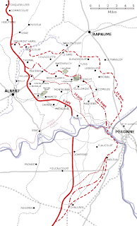
These were some of the maps that I used to help me draw in the front lines on ArcGIS Online. After I drew these front lines I did a lot of my research using the site, Somme. This site helped me to find the specific battle location on the Somme and landmarks that were significant to the battle. With the addition of the landmarks you are really able to see how the geography of the land helped shape the front lines throughout the battle. You will be able to better see my methods for using the Map Notes in my Week 7 Blog Post (http://geog368.blogspot.com/). Also in my Week 7 Blog Post you can view a screen shot of my process of research as I gained more indepth information on The Battle of the Somme. After I had completed my map I pulled it up into ArcGIS Explorer Online. This enabled me to create slides where I could turn on and off layers to tell a story of The Battle of the Somme.

Final Project: My final project is in presentation mode. I created my map and all of its features using ArcGIS Online and then opened it up into ArcGIS Explorer Online. This enables me to create several slides and walk you through the battle slide-by-slide. I started off with a slide of the first day of battle. This slide has all of the mine explosions on it. What is awesome about this format is that the user can drag their mouse over a feature to see what it is and then click on the feature to get a more in-depth description of that feature. Then I went from battle-to-battle showing visually how the battle progressed.


Monday, November 25, 2013

Week 7

Tasks

  • Research more on the Battle of the Somme and find more things to add to my front lines map
  • Add new material to the front lines map
  • Georeferencing


Research

As I began doing more research on the Battle of the Somme to add to my front lines map I was finding so much great information that I could use, but for some reason it was really hard for me to visualize. So I decided to print off a blank map of the front lines of the Battle of the Somme. I used this to draw on and write notes to keep my thoughts straight.


The blank map I used for my notes


The first thing I decided to add to my map was the other mine explosions that happened on the first day of the battle. On the pre-modified map I only had the Lochnagar and Hawthorn Ridge craters. These were the only ones that I really knew about because we visited these sites during our class trip to Northern France. In total there were eight large mine explosions and eleven small mine explosions.

  • At the Lochnagar site there was one large mine and two small mines that were detonated.
  • At the Hawthorn site there was one large mines that were exploded.
  • At the Y-Sap site there was one large mine explosion.
  • At the Tambour site there were three large mine explosions all detonated near each other.
  • At the Mametz site there were two large mine explosions, one at Bulgar Point and one at Casino Point, surrounded by nine other small mine explosions.


A picture of how Lochnagar Crater looks today


Now that I have all of the mine explosions located on the map I believe it gives the viewer a better idea (visually) of the events that took place on the first day of battle and how such an extravagant beginning led to such an uneventful battle.

After locating the mine explosion locations I decided to break down the Battle of the Somme by the smaller battles that happened within the five months leading up to the end of the battle.


  1. The Battle of Albert (July 1 - July 13) - This battle led to the capture of Mametz Wood, the city of Contalmaison, and Trones Wood.
  2. The Battle of Bazentin Ridge (July 14 - July 17) - This battle was an assault from the city of Bazentin to the city of Longueval.
  3. The Battle of Delville Wood (July 15 - September 3) - This battle led to the capture of part of Delville Wood and the whole of the city of Longueval.
  4. The Battle of Pozieres Ridge (July 23 - September 3) - This battle led to the securing of the city of Pozieres.
  5. The Battle of Guillemont (September 3 - September 6) - This battle led to the capture of the city of Guillemont and part of Leuze Wood.
  6. The Battle of Ginchy (September 9) - This battle led to the clearing of the city of Ginchy and the capture of the rest of Delville Wood.
  7. The Battle of Flers - Courcelette (September 15 - September 22) - This was when tanks were first introduced into the Battle of the Somme. This battle led to the capture of the city of Flers and the clearing of High Wood.
  8. The Battle of Morval (September 25 - September 28) - This battle (with the assistance of a tank) led to the capture of the cities of Morval, Lesboeufs, Gueudecourt, and Combes.
  9. The Battle of Thiepval (September 26 - September 28) - This battle led to the capture of the city of Thiepval and a German strong point located of Mouquet Farm.
  10. The Battle of Le Transloy (October 1 - October 18) - The objective was to capture the city of Eaucourt L' Abbaye. This mission was unsuccessful.
  11. The Battle of Ancre Heights (October 1 - November 11) - This battle led to the capture of the Schwaben Redoubt (a german strong point) and the temporary capture of the Regina Trench.
  12. The Battle of Ancre (November 13 - November 18) - The objective was to secure the area between Beaumont-Hamel and Serre. This mission was unsuccessful.

The blank map after I added all of my notes and illustrations


Adding New Material

Now all I had to do was add the new information I had acquired onto my pre-existing front lines map of the Battle of the Somme. The first thing I did was I added the new craters and wrote descriptions for each of them. I wasn't a huge fan of the symbol I had originally chosen for the craters (The red triangle with an explanation point in the center), so I chose a new symbol that is orange and somewhat resembles an explosion. 

Picture of the newly added mines with their new symbol

While I was adding the new mine craters I was placing them in the positions that history has shown they were in I figured out that my original front lines were not exactly in the correct position. This put a lot of the mine explosions well behind the front line from the beginning of the battle on July 1st. So I made the executive decision to re-draw all of the front lines from the Battle of the Somme. Something that was different this time was instead of using the free-hand drawing tool I used the regular line tool where you keep clicking and it automatically connects the dots. This was much easier for me because the free-hand lines were very touchy and I would keep messing up. Along with the correctly placed mine explosions and the fact that I've drawn these lines about 5 times for each date, I added other features that were significant to the battles within the battle to help me re-draw the front lines. To my front lines map I added the land marks; the Schwaben Redoubt, Mouquet Farm, High Wood, Bazentin Wood, Mametz Wood, Delville Wood, Trones Wood, and Leuze Wood. 


Map of the land marks I added that were significant to the battles


While these land marks helped me draw the front lines for each date, you can also see how they really helped to shape the front lines. The lines tend to go around certain points, which shows you at that date who controlled what land marks. 

After I finished adding all of the mines, land marks, and re-drawing the front lines it was time to begin adding the battles to the map. This is something I had to think about for a while because I wasn't exactly sure how to represent the battles of the map with the tools that were available to me. I decided to draw circles around landmarks and cities that were important in the battle and then adding a flag near the circled items to give a description of the occurrences from the battle. As an example I will show you the battles of Albert and Bazentin. 


The Battle of Albert

The Battle of Albert is represented by circles around Mametz Wood, the city of Contalmaison, and Trones Wood. I just used the circle line tool to draw the circles. These are the land marks that were captured by the British in the Battle of Albert. There is then a green flag you can click on which represents that the objectives of this battle were achieved. This information explains the occurrences during this battle. 

The other type of explanation for a battle I has used thus far would be how I represented the Battle of Bazentin.


The Battle of Bazentin

The Battle of Bazentin is represented by an arrow starting at the city of Bazentin and pointing to the city of Longueval. This shows the assault towards Longueval that happened during these days. As you can see there is no need for the informational flag in this battle because there is only the one feature. All of the information can be found by clicking on the arrow. 

Something I found out while I was working on the Battle of Bazentin was when you draw a line you can double click on it and the program adds extra points to the line that you can move to your liking. This is how I made the arrow curve. This would have been nice to know when I decided to re-draw the front lines. I possibly could have just moved the lines, but by then I had already completed that task. 

So far I have only added up to the Battle of Morval on my map, and already I have come to a realization. To present this map I will need to turn on and off each battle as I show it, because all together the map looks very clustered and doesn't make sense.


Clustered front lines / battles map


Georeferencing

There are several maps I have that I'm going to georeference. Georeferencing - Aligning geographic data to a known coordinate system so it can be viewed, queried, and analyzed with other geographic data. Georeferencing may involve shifting, rotating, scaling, skewing, and in some cases warping, rubber sheeting, or orthorectifying the data (As stated by Esri Support).

First what you need to do is add a basemap and locate the area that you are going to be focusing on. After you have found your area of relevance you will click the Add Data button and click on the map that you are wishing to georeference. When ArcMap attempts to upload the map a pop-up will occur on your screen. This pop-up is just explaining that the map your are attempting to upload cannot be projected because it does not have any spatial reference. Which pretty much means the map doesn't have coordiantes so ArcMap is unsure as to where the map you uploaded should be placed on the basemap. You will just click ok and the map will be placed in a random spot on the map. The next step is to pull up the georeferencing toolbar. This is found by clicking on the Customize tab, clicking on toolbars, and selecting to bring up the Georeferencing toolbar.
 

The Georeferencing toolbar will look like this
 
 
Next you will click the Viewer tool on the toolbar and this will bring up your selected map. After that is brought up you will choose the Add Control Points tool on the toolbar. To begin the georeferencing process you will click on a specific point on the map that you uploaded, and then click on the same point on the basemap. You will continue to do this and the ArcMap program will shift the map to fit on the basemap.


A map of the front lines of the Battle of the Somme that is georeferenced
 

Question: What do I do with a photo once it has been goereferenced?

 
I am attempting to find photos that I could georeference of the front lines for the individual battles of the Somme. I had maps but they didn't have enough geographical points, which is necessary to accuratly georeference a map.
 
 
While looking for trench maps of the Battle of the Somme I found this legend that explains what all of the figures on the map mean. Most trench maps don't have a legend that go along with them.


Monday, November 18, 2013

Week 6


Tasks

  • Begin to dig into the books that I checked out from the McIntyre Library
  • Add descriptions to the features on my ArcGIS Online front lines map
  • Continue searching for more useful sources
  • Road blocks
  • Future Goals


Literature


The Somme: The day-by-day account

This was the first of two books that I rented from the McIntyre Library. When I decided to check this book out I had only skimmed throught the pages, but I was intrigued by the numerous amount of maps that it contained. But once I started to look into the book I realized that this wasn't what I was expecting and it wouldn't help me with where I wanted to go with my project. My project for the Battle of the Somme is a very broad overview of the battle with focuses on key events and the change in the front lines throughout the battle. This book was very, very specific as to what happened each day and even the slightest movement or action of each regiment. The maps in this book were magnificant, but much too specific for my project that I am working on.


The 1916 Battle of the Somme

This was the second book that I rented from the McIntyre Library. Right away this book caught my eye because it seemed to be written in the same format as the project that I am working on. It takes the battle in chunks and focuses on the main events for a certain amount of time.
 
This book begins with a chapter on the concept, planning, and preperation for the Battle of the Somme.  Before the Battle of the Somme General Joffre stated, "We have to destory the moral of the German army and nation." While that may have been the main goal of the overall war, the Battle of the Somme was more in order to divert attention. "The original objectives were; 1) to relieve the pressure on Verdun, 2) to assist our Allies in the other theatres of war by stopping any further transfer of German troops from the Western Front, 3) to wear down the strength of the forces opposed to us." This chapter also focuses on the processes of obtaining artillary and the training of infantry men.


The second chapter in this book is The First of July. The beginning of this chapter goes through maps of the cities Montauban, Mametz, Fricourt, Ovillers La Boisselle, Thiepval, Beaumont Hamel, Serre, Gommecourt and shows the allignment of trenches and front lines of each side. Also talked about were the mine explosions during the first day and of course the massacre that took place on the first day.


An example of a trench map located in this chapter


Another topic located in this chapter was message sending edicate on the front lines. This included what was, and was not acceptable to send over the lines.


The five orders for message sending on the front lines
 
 
This is as far as I've gotten in this book thus far. I will continue to keep digging for more information as well as continue to look for more sources to complete my project.


Descriptions

 
In my previous blog I showed you the project I had strated on my map from the front lines of The Battle of the Somme, but I had not yet inserted the descriptions for each feature I had put on the map. But before I did that I found out you can add a summary and description for the entirety of the map. So this is what I decided to work on first. To get to this all you had to do was before you enter the map there is a button on the toolbar that says edit. Clicking that enables you to edit those certain features. For the summary I just put the beginning and ending dates of the battle, July 1, 1916 - November 18, 1916. After that I inserted a summary of the significace of the battle and what my map will be showing you.


After I completed this I continued by adding descriptions to each individual feature. 
 
Feature Descriptions
The Hawthorn Crater was the explosion that was caught on film and is used in almost every WWI film. The Lochnagar Crater was the single largest mine explosion in all of WWI and is now a memorial. The front line of July first when the mines were exploded and the British charged into no-man's-land, only to be slaughtered by German machine guns. The front line of July 14th where a series of artillery bombardments help the British to gain more ground. The front line of September 15th which was gain through the use of tanks by the British. The front line of November 18th which was the final day of the battle. And finally the arrows that show the direction of movement for the front lines and the British pushed back the Germans at the Somme.
 
 
An example of the description editor
 
 
So after I added all of the descriptions you can then exit the editor mode and when you click on a certain feature the name and description of that feature will be shown.


 An example of when you click on a feature and the title and description that appear near the selected feature


Additional Sources

 
I found another site that talks about the end of the war in casualties. The site states ,"The final tally included 420,000 British casualties, 200,000 French and the Germans 500,000. The reward for this effort was the six-mile movement of the British front line into German territory." I really like this quote because it does give you hard numbers on the amount of men that were lost by each side in a matter of five months or so. But then, almost sarcastically, it calls the six-mile movement of the front lines a "reward". This shows you why so many felt this war was a waste of resources with the amount of casualties compared to the amount of land gained by the Allies.


Road Blocks

 
This is something I had brought up last week, but I would really like to be able to put my map into a template to make it more viewer friendly. The only problem I have had with this is the legend on the ArcGIS Online site seems to be un-editable. While I could very well work around this it would mean that I would have to describe what each feature represents, when a legened could do that for me. I had tried putting my map into several templates and I do believe I have found one that I am fond of. This template would allow the viewer to see the map, read a description of the battle, and view the legend to know what each feature represents. Now with my lack of being able to edit the legend you can see why this would be considered a road block for me. Hopefully I can get that figured out becuase I think that template would accent my map very well.


This is what my map would look like in this template, as you can see the legend is not up to par


Hopefully I can figure out the legend, add a more in-depth description of the battle, and produce a map that is not only pleasing to those who wish to become more knowledgable, but also visually pleasing to the random viewer.


Goals

 
For next week I hope to get a solid start on my picture story map of the Battle of the Somme. Now that I have a majority of the sources I will use for this project at my disposal I believe this will come along quite smoothly. Also I hope to figure out the legend on my ArcGIS Online map and compete that project as well.


Monday, November 11, 2013

Week 5

Tasks

  • Explain my decision to not use the CSV.
  • Describe how I created the front lines map on the ArcGIS Online site and give a little bit of a historical background behind each movement.
  • Talk about where I go from here and my next project I will be working on.


CSV Decision


So last week I talked about my difficulties with the CSV template and how I was unable to figure out the thumbnail template. After thinking about it for a while, I decided to not use the CSV template. Even though while working with story maps the CSV can be very useful in the long-run, for my project I do not think I will be working long enough to see the benefits of the CSV. I believe it would bring me more difficulties than it would benefits, and that is why I am choosing not to use a CSV for my final project story map.


Using Arc GIS for Front lines map
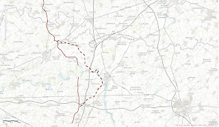

Last class period I made the decision to continue with my idea of making a map of the front lines through out the battle of the somme. The idea being there will be a map where you can turn on and off layers that specify certain days. Each day will have a different front line and information on the events leading up to the shift in the lines. To start this project their needed to be a basemap for which the front lines could be drawn. I located the correct area of the Battle of the Somme through my knowledge from visiting the sites and from various maps.

The Battle of the Somme occured north of the Somme River as to try to divert attention from the German troops in Verdun. The hope of the Allies was that the Battle of the Somme could be used to flank the Germans and catch them off gaurd. The French were getting hammered at Verdun, and the Somme was more of an act of despiration than anything.


After the Allies chose this area to begin their attack they needed a plan. The British believed that they could plant a series of explosives underneath the German lines without them knowing. On the morning of July first the British planned to blow-up their explosives and with the Germans so caught off guard, be able to walk to the German front lines. The explosives were a major failure and the British were slaughtered in the tens of thousands.... on the first day. The British has approximatly 58,000 casualties on the first day alone.

Using the various maps of the front lines from the Battle of the Somme (see below for various maps), I drew a line of the front lines where they were located on the morning of July 1st. I did this by clicking add, add map notes. There is then an option to draw a free-hand line. This is how I was able to draw the front line on the map of the Somme.


July 1st


The British then made another small gain on July 14, 1916. This movement in the front lines was made through a series of artillery bombardments. And that would be the story of this battle, a battle of many small, insignificant gains. For this reason there were many that believed this battle had been unnecessary. Their opinions were based on the fact that an enormous amount of lives were lost with minimal military gains.


July 14th


As you can see for this line I used a dashed line. This will give the viewer a better visual on the movement of the front lines. This was done by clicking on the edit button located on the toolbar. Once in that mode the user can click on any feature that was previously created and a tab will pop up with a number of different options for editing. You can then click on the change symbol button to change things such as color and line type.


The next gain in the front lines was on September 15th. This gain was brought most significantly by the use of tanks for the first time in this battle. I illustrated this by using an even tinier dashed line to, once again, show the progression of the Allies as they moved East.


September 15th


The final front line I drew was at the end of the Battle of the Somme in November 18, 1916. General Haig called an end to the fighting on this day. After thousands of casualties and minimal gains this battle was seem by many as a waste of resources. Was the loss of all these soldiers worth the diversion of attention to keep Verdun in the hands of the French worth it? I guess that is for you to decide.

 
November 18th


I once again used an even smaller dashed line for this date. For this line I also used pins to help me locate where the line was supposed to be placed. I placed these pins on the map on major cities that the front lines either passed through or came near to. After I was finished drawing the front line I would delete the pins to make the map look neat and professional. After finishing the front lines on the map I decided to insert arrows to show which way the lines were moving. The lines go from solid to dashed to try to show the direction of movement, but I believe the arrows are a better visual representation. I also inserted a symbol to show where the explosions of the Lochnagar and Hawthorn craters were located on the first day. While there were many more explosions than just at these two locations I am focusing on these becuase these are sites that we visited while we took our trip to France. Focusing on these two sites is awesome for me because we visited those sites in person and now I can look at a map and see the exact location and the significance that they had on the battle.


A picture of our visit to the Lochnagar Crater


Various front line maps: Front Lines 1; Front Lines 2; Front Lines 3
 
Unfinished frontlines map: Battle of the Somme


Story Map


I am currently in the process of gaining information for this project. I want to make a picture story map of key events and figures that played a large role in the Battle of the Somme. While I don't have a start on this project to display I do have an assortment of links and a few books that have been/ will be very useful to me while gaining information. Two books I have rented from the McIntyre Library are The 1916 Battle of the Somme: A Reappraisal by Peter H. Liddle and The Somme: the day-by-day account: by Chris McCarthy.
 
This will be the project I will start to work on for this next week, along with fine tuning and finishing up my interactive map of the front lines. I have yet to add the descriptions to the points and lines on the map. I'm also sure there will be other things I think of to add to my front lines map so I wouldn't consider it finished by any means. Once I finish both the front lines map and the picture story map I will have a full historical summary of the events that happened at the Somme from the beginning to the end of the battle.


By clicking on the edit tab on the toolbar you can then click on any feature and add a description to that line, point, or area


One idea I had focusing on the front lines map was I want to be able to edit the legend. Once I am able to edit the legend I would be able to insert my front lines map into a template to make it look more professional. Hopefully I can do a little bit of searching and figure that out by next week.


Monday, November 4, 2013

Week 4

Gettysburg Story Map


With my idea being to take the template used in the Gettysburg Story Map to create my story map of the Battle of the Somme I began to look at the ArcGIS Online story map site. All story maps created with using the Create Map button. This will bring you to a blank map where the user begins their project. After picking an appropriate base map I zoomed to the area in France north of the Somme river where the Battle of the Somme took place. Now you have the ability to add layers which I would need to get an interactive story map like the Gettysburg Story Map to work. But, obviously, with there being no pre-made layers on the ArcGIS site for the Battle of the Somme they would need to be created.

Another option that is available would be to draw on the map. To do this you click the Add button and then click the Add Map Notes button. This will bring you to a screen that gives you the ability to name the Map Note. After you name it you hit complete and the Edit: Add Features bar will appear to the right of the map. You can then draw on the map. I thought this map be an option to draw the several frontline changes throughout the battle by using this and then setting a date to each Map Note. The idea would be to add this to a Story Map template and the seperate Map Notes (with their predetermined dates) would be displayed. I was unable to figure out how to assign dates to the Map Notes. After playing around with this for a while I made the decision to go simpler with my Story Map and use the picture story map template. While this template won't be as sophisticated as I would have hoped for my final project in this class it will still get the job done and enable me to turn in a quality story map.


Creating a CSV


After changing my mind on the sort of template I will be using for my final project I decided to start to create a CSV to host my pictures. This will become beneficial once the process of starting the story map takes place. When you go to add pictures into a story map, instead of uploading all of the pictures and placing them in the correct position, you can simply upload your CSV file and all of the photos will be put into place for you.

A CSV is an Excel file that contains information about a photo, like; name, description, icon color, longitude, latitude, picture url, and thumbnail url.


For the name and description those are up to the user. The icron color our CSV used was red. To find the lattitude and longitude of the photos I had to go to other people's photos that had GPS enabled. My iPhone should have had the coordinated connected to each photo, but this was only true for about a fourth of the photos. Possibly just a lack of GPS signal. For the picture url we used the url; https://gis.uwec.edu/Geog368Fall13/(yourusername)/photoname. For example my user name is johnblak and a name of one of my photos was LochnagerCrater, so the picture url would have been; https://gis.uwec.edu/Geog368Fall13/johnblak/LochnagerCrater. The user name locates the picture by the album that I had created and then uses the specific picture name to find the exact photo.

A problem I encountered was with producing the Thumbnail URL. I tried using a thumbnail url generator that was located online, but it wouldn't work. I would past my JPG photo and press generate. An error would occur saying that only PNG and JPG were supported with this generator. Since I was using a JPG photo I'm not exactly sure what the problem is.


This is the error message that would appear when I attemped to obtain the thumbnail url


Site used for thumbnail url: Thumbnail Generator

Final Project Progress


With my CSV not yet being completed due to some technical difficulties I have continued brainstorming information for my final project and how it will be completed. I am going to use the ArcGIS site and use a picture story map template for my final project.
 
 
On the right is a map with specific points on the map, on the left will be a title, picture, and a description of the events that happened at that certain place. With a focus on the Battle of the Somme, most of the events will be located around the Albert, France area.
 
 
So far, my points of emphasis for this project will be the significance of Joffre and Haig in the battle and how their decisions benefited and worked against the allies. The significace of the dates July 1, July 14, September 15, and November 17, 1916 with the movements of the frontlines throughout this battle. And key events such as the start of the battle, lochnager crater, hawthorn crater, the massacre, and the end of the battle. One site I found, http://www.spartacus.schoolnet.co.uk/FWWsomme.htm, focuses on all of these points and I also hope to find more sites and possible some books that go more in depth. I have not had the chance to look at any of the books that I had stated in my previous posts that I would, but I hope to dig into those sometime later this week.


Lochnagar Crater Site


Hawthorn Crater Site
 
 
I believe if I go in depth in the topics that I have chosen the viewer will have a much better understanding of the Battle of the Somme, the significance it had during WWI, and the geographical implications it had on Northern France.